Future AI Flying Robot
Smart City Architecture
Large-Scale Digital Airspace Governance Platform & Provider Integration Blueprint
Digital Airspace Governance Infrastructure
Next-Generation AI-Powered DaaS Service
HOLLYWAY Drone
Responsible for City Inspection & Security.
HOLLYWAY DOCKING
Automated Logistics Station.
A2-C01 VTOL
Light Logistics (<5KG), Long-Endurance Reconnaissance.
Cloud & City Integration
Airspace Service Layer
(UTM Digital Platform)
HOLLYWAY Inspection
A2-C01 Surveillance
HOLLYWAY DOCKING Station
HOLLYWAY Light Logistics
AETHERLAND's true mission is as an Airspace Infrastructure Company. Like AWS provides cloud computing or VISA provides a global financial network, AETHERLAND provides a unified UTM and digital service platform. We do not directly limit drone brands but instead establish interoperability standards.
Interactive 3D
Explore Our Product Lineup from Every Angle
HOLLYWAY Drone
City Inspection & Security
Digital Twin Airspace Architecture: Integrated Physical Assets and Urban Brain.
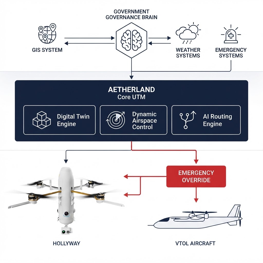
GOVERNMENT / CITY
Governance Brain
AETHERLAND CORE UTM
Digital Twin Engine
Real-time state regulation & simulations
Dynamic Airspace Control
Geofencing, Route Planning, Deconfliction
AI Routing Engine
Optimal gateway computation for diverse assets
UTM Governance for Cross-Brand Operations
Airspace Infrastructure as a Service (AIaaS): Building Open and Interoperable Airspace Standards.
Shared Airspace
Drones from various brands can safely share the same airspace.
Shared Infrastructure
Different tasks share AETHERLAND's AI computing and communications infrastructure.
Unified Monitoring
Local governments conduct digital twin holistic monitoring interface.
Client Freedom
End clients can freely select the most suitable aircraft based on their mission needs, without being tied to a single piece of hardware.
Every service deployed in each country must comply with aviation safety regulations and implement flight safety protocols.
AETHERLAND: The Internet of the Sky in the Drone Era
From Hardware Islands to Commercial Deployment:
Standardized Provider Onboarding Process
Step 1
Manufacturer Registration
Step 2
API Standardization
Step 3
Digital Twin Sync
Step 4
Shared Airspace Validation
Step 5
Operational Deployment
Certified &
Connected to Shared Airspace
Project Update:
- ●HOLLYWAY: Entered Phase 3 (Digital Twin Sync) individual connection testing, preparing for field validation in Japan.
- ●REVATECH: Entered Phase 3 (Digital Twin Sync) individual connection testing, preparing for field validation in Japan.
[CONFIDENTIAL] Japan-Taiwan Strategic Blueprint, System Version: UTM-DT-01
This is where the drone becomes a system.
A drone is only one part of an intelligent flight operation.
AetherLand connects the aircraft, sensors, communication, AI and mission control into one system.
Building a Unified Airspace Language: From Raw Data to 3D Digital Twin Visualization
{
  "drone_id": "AET-001",
  "position": {
    "lat": 35.0000,
    "lon": 139.0000,
    "alt": 120
  },
  "velocity": 15,
  "battery": 78,
  "mission_status": "ACTIVE",
  "remote_id": "RID-XXXX",
  "risk_level": "LOW"
}
3D Digital Twin Visualization
ALT: 120m
position → alt
Real-time geospatial sync to digital twin with <1m precision.
78%
battery
Live battery telemetry mapped to visual HUD indicators.
RISK: LOW
risk_level
AI risk prediction engine evaluating collision probability in real-time.
Lightweight, standardized API architecture (Telemetry & Emergency API) allows any compatible drone status to be mapped with <1m precision and zero latency into the AETHERLAND virtual airspace, forming the foundation for real-time collision avoidance and risk prediction.